
10 Oceania
Learning Objectives
- Identify the key geographic features of Australia, the Pacific, and the polar regions
- Describe the biodiversity found in Australia and the Pacific
- Explain the patterns of human settlement in Oceania
- Analyze how climate change is impacting the geography of Oceania
10.1 The Physical Landscape of Oceania
Oceania is a realm like no other. Nowhere else in the world can one find some of the unique wildlife that is found in this realm, and no other region is as isolated. Oceania is the only world region not connected by land to another region. This is a region of the world at a crossroads where the effects of global changes in climate and pollution could have profound effects. The region of Oceania includes Australia, the realms of the Pacific Islands, and the polar regions of the Arctic and the Antarctic. While some regions share a distinct cultural or colonial history and others share a common physical landscape, the region of Oceania is connected more by its isolation than by a shared physiography or human experience.
Australia dominates the region in terms of size, economics, and population. The country has the unique designation of being both a sovereign state and a continent. Often, Australia and New Zealand are considered a single region (see Figure 10.1), but while the two countries share cultural and historical similarities, their physical landscapes are quite different. Australia lies in the middle of its own tectonic plate making it relatively geologically stable. Australia has no active volcanoes and has had only a small number of large earthquakes. Its tectonic position also limits its relief and much of the continent is relatively flat. An exception to this is the Great Dividing Range which runs along the coast of Eastern Australia. This series of mountain ranges affects Australia’s climate by providing orographic rainfall along the coast and divides the core population center of Australia from the rest of the continent.
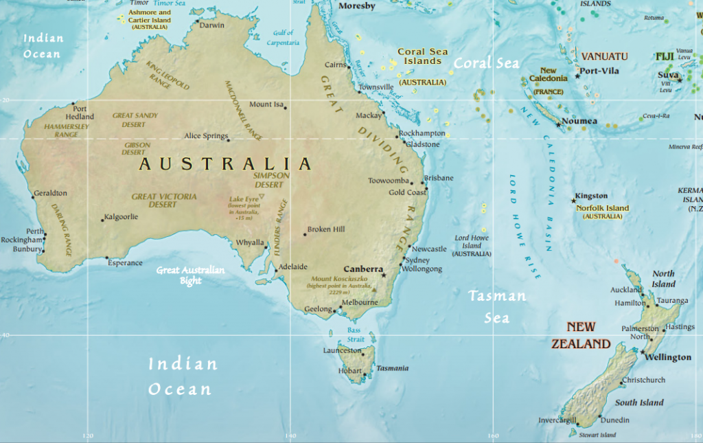
The other key geographic feature of Australia is its vast interior known as the Outback (see Figure 10.2). This remote area of extensive grassland pastures supports one of the world’s largest sheep and cattle industries. However, the ecosystem of the Outback is quite fragile. With limited precipitation and vegetation, overgrazing puts the region at risk for desertification. In addition, although this region was the center of population for Australia’s indigenous groups, ranching in the Outback has created issues of land ownership.

One of the most well-known features of Australia’s geography lies just off coast: the Great Barrier Reef. This massive underwater reef is the world’s largest coral structure and stretches over 2,300 kilometers (1,400 miles). However, warming ocean temperatures and pollution have been a significant environmental threat to the Great Barrier Reef in recent years.
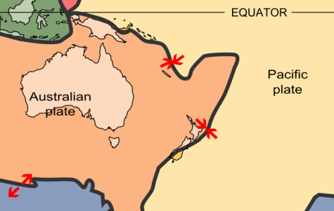
Unlike its geologically stable neighbor, New Zealand is situated at the intersection of the Pacific Plate and the Australian Plate (see Figure 10.3). Its two large, mountainous islands and numerous small islands are prone to both earthquakes and volcanoes. New Zealand is younger than Australia geologically and has a far more varied topography. On New Zealand’s North Island alone, you could spend the morning surfing on a sandy beach, the afternoon picnicking in the rolling green hills where the fictional city of Hobbiton was filmed, and the evening skiing on an active volcano, Mount Ruapehu. New Zealand’s South Island is home to a number of stunning fiords, more commonly found in Scandinavia where they are spelled fjord.
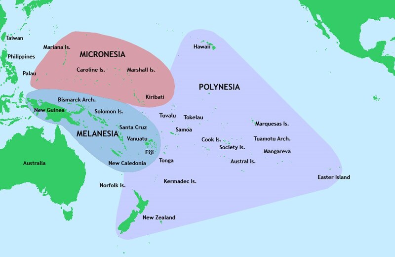
The islands of the Pacific to the north and east of Australia and New Zealand are divided into three regions (see Figure 10.4). New Zealand is part of the islands of Polynesia, from the prefix “poly” meaning “many.” Polynesia is a large, triangular region stretching from New Zealand to Easter Island to the Hawaiian and Midway Islands. West of Polynesia and to the northeast of Australia are the islands of Melanesia, including New Guinea, the Solomon Islands, and Fiji. Europeans called the region “Melanesia” from the Greek prefix melan- meaning “black,” referring to the darker skin they believed characterized the people of this realm. North of Melanesia are the tiny islands of Micronesia, from the prefix “micro” meaning “small.” There are over 2,000 islands in Micronesia.
The islands of the Pacific can be divided into two groups based on their physical characteristics. The high islands like Hawaii are volcanic, meaning they were formed from volcanoes, and thus have a relatively high relief. This high relief and volcanic soils enables the high islands to have fertile soil and ample rainfall, which in turn supports a diverse agricultural system and relatively large populations.
In contrast, the low islands of the Pacific are comprised mostly of coral and, as their name implies, are generally low in elevation. Most of the islands in the Pacific, particularly in Micronesia, are low islands. These islands may only rise a few feet above the water and their dry, sandy soil makes farming difficult. Fresh water is often in short supply in the low islands. As a result, these islands typically have much smaller populations. The relatively large coral island that comprises the country of Niue, for example, rises to a maximum 60 meters (less than 200 feet). The low elevation of these islands make them vulnerable to natural disasters, such as tropical cyclones, and to changes in sea elevation due to rising global temperatures. In the country of Tuvalu, an island chain located between Hawaii and Australia, the highest point is a mere 4.6 meters (15 feet) above sea level and the island has sustained severe damage from cyclones during its history.
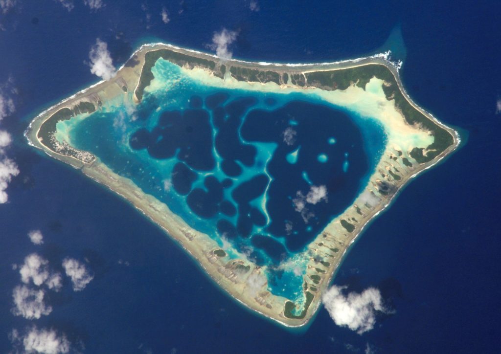
A number of low islands of in the Pacific form atolls, ring-shaped chains of coral islands surrounding a central lagoon (see Figure 10.5). Typically, the lagoon is actually a volcanic crater which has eroded beneath the water. Most of the world’s atolls are found in the Pacific Ocean and their land areas are generally quite small.
In general, the islands of the Pacific have warm, tropical climates with little seasonal extremes in temperature. Some islands experience seasonal, primarily orographic rainfall. These relatively warm temperatures help support tourism throughout the region. Throughout New Zealand and the core area of Australia, east of the Great Dividing Range, is primarily a maritime climate. This climate zone features cool summers and winters with few extremes in temperature or in rainfall.
Also included in Oceania are the earth’s polar regions. In the North Pole is the Arctic Ocean, the world’s smallest and shallowest ocean. Although it may appear to look like a landmass covered in snow on many globes, there is no landmass below the North Pole. The ocean is covered by a sheet of sea ice throughout the year and the entire body of water is almost completely ice-covered in winter. In the South Pole is Earth’s southernmost continent, Antarctica. This continent is around twice the size of Australia and is almost entirely covered with ice. It is not home to a permanent human settlement.
10.2 The World’s Oceans and Polar Frontiers
Over 70 percent of the entire surface of the world is covered with water, but who controls it? If the body of water is inland, ownership is quite clear. A lake in the interior of a state belongs to that state. For the 96.5 percent of the world’s water that’s held in oceans, however, ownership is much less clear. Historically, the world’s oceans were considered the “high seas” and while states had control over their immediate coastline extending out three miles, the vast stretches high seas were free from ownership. As ocean resources became more important, however, countries became interested in establishing clear rights to minerals, oil, and fishing stocks offshore.
In 1945, President Harry S. Truman announced that the sovereign territory of the United States extended to the boundary of its continental shelf, which was in some places hundreds of miles offshore. Other countries, including Chile, Peru, and Ecuador, followed suit, beginning an international dash to claim offshore waters. Within two decades, countries were using a variety of systems of ownership; some claimed waters three miles offshore, others 12 miles, and still others maintained ownership over all of the waters to the continental shelf.
Eventually, the United Nations intervened, seeking a universal system of ocean ownership. The United Nations Convention on the Law of the Sea (UNCLOS) resulted from series of international conferences and established guidelines for maritime travel and control of natural resources found in the world’s seas. As a result of the UNCLOS, there are now several categories of ownership over the world’s water depending on its distance from shore (see Figure 10.6). A state’s internal waters are considered the sovereign territory of a state. Territorial waters extended 12 miles offshore and are also considered sovereign territory of a state. However, in territorial waters, a state must grant “innocent passage” to oceangoing vessels, meaning it must allow the vessel to pass through as long as it is doing so in a speedy manner that is not threatening the security of a state. Beyond the territorial waters, a state can control certain aspects of a 12 mile contiguous zone, including taxation and pollution. Following the US claim of control over the continental shelf, the UNCLOS established that a 200 mile zone extending out from a country’s coastline was its exclusive economic zone, or EEZ, where it has exclusive control over any natural resources. Other countries can fly over or pass through the waters of the EEZ, but cannot use the resources within. However, countries are free to sell, lease, or share the rights to their EEZ. Beyond the EEZ are international waters where no state has direct control.

As a result of the UNCLOS, some tiny islands gained immense stretches of ocean territory – and the rights to the resources in and underneath those waters (see Figure 10.7). Some countries found this as an opportunity to expand their resource area. Conflicts developed over what would otherwise be tiny specks of island territory but what had become over 100,000 nautical miles of ocean resources. Particularly as the technology for offshore drilling improved, states sought to secure control of what could be huge caches of oil and minerals.
The UNCLOS also established some ownership over the Arctic Ocean. Russia, Norway, Canada, the United States, and Denmark, which controls Greenland, all have overlapping EEZs in the Arctic. Historically, this frigid, isolated region was of little interest to countries. Early attempts at exploration were largely unsuccessful and a person wouldn’t reach the North Pole until the early 20th century. However, the drive to secure fossil fuels has led to more intensive research and exploration in the region and as much as one-quarter of the entire world’s oil and natural gas reserves are believed to lie below Arctic waters. Global increases in temperature could further open up previously inaccessible areas of the Arctic to drilling operations. A 2015 declaration signed by all five states surrounding the Arctic prohibited fishing in the central Arctic Ocean in an effort to protect ocean life and resources.
In the South Pole, Antarctica remains a frontier region with no permanent human inhabitants, though the continent is home to penguins, fur seals, and other marine creatures. Antarctica does have a number of research stations as well as an Orthodox Church and a few thousand people work in and around Antarctica in various times of the year conducting scientific research. Antarctica is the coldest place in the world, once dropping down to -89.2 °C (-128.6 °F) at a Russian research station. Although Antarctica might look relatively moist and snow covered, it is actually a desert with very little precipitation.
So who controls this vast expanse of frozen desert? The answer depends on who you ask. Several different countries claim control of Antarctic territories (see Figure 10.8) but, in general, these states do not recognize each other’s claims.
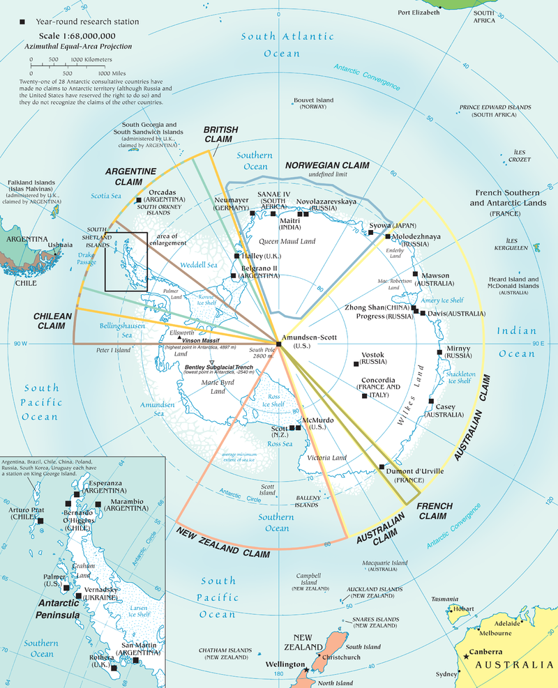
In 1959, the Antarctic Treaty was signed that put a hold on new territorial claims, established Antarctica as a zone for scientific research and environmental protection, and prohibited military activity in the region. A later treaty signed in 1998 reaffirmed Antarctica as a peaceful, scientific frontier and prohibited mining on the continent.
10.3 Biogeography in Australia and the Pacific
The relative isolation of Oceania defines it as a region but has also contributed to perhaps its quirkiest characteristic: its distinctive wildlife. Biogeography is a branch of geography that explores the spatial distribution of the world’s flora (plant life) and fauna (animal life). While every world region has its own, unique plants and animals, some of the creatures found in Australia and the Pacific are found nowhere else on Earth. A number of world regions have an impressive degree of biodiversity, meaning there are a wide variety of species present. These regions are generally located in the tropics. British biogeographer Alfred Russel Wallace was one of the first to try and determine the boundary of Australia and Southeast Asia’s unique plants and animals
in the 19th century.
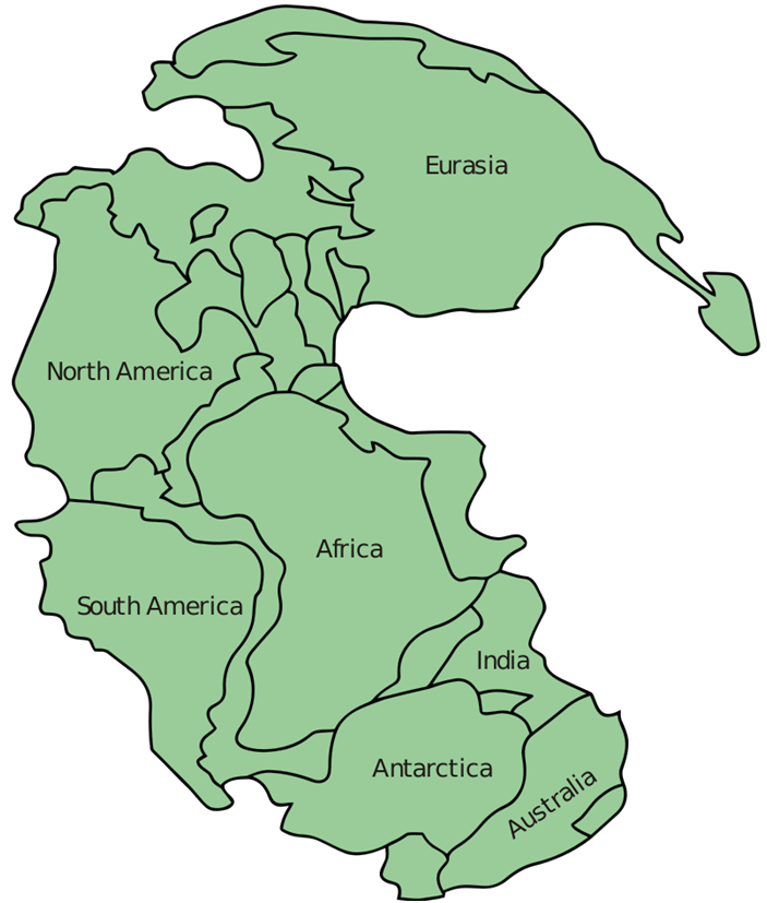
Geography is more than the where, however, but is also a discipline that asks “Why?” Why does Australia have such unique, and frankly a bit frightening at times, flora and fauna? Why are monotremes, mammals that lay eggs rather than give birth to live young, only found in the isolated region of Australia and New Guinea? It is the isolation of this region that’s key. 200 million years ago, Australia was situated on the far-reaches of Pangaea, the last supercontinent (see Figure 10.9). Around 175 million years ago, Pangaea began to break apart. During the same time period, the earliest mammals were evolving, diverging first from egg-laying reptiles and then continuing to adapt and change. Early egg-laying monotremes were found throughout Pangaea but eventually went extinct in the other world regions, out-competed by more evolutionarily advanced mammals. Australia and New Guinea, however, broke away before more advanced mammals arrived, and thus monotremes remained. The only modern monotremes are the platypus and the echidna.
In addition to monotremes, Australia is home to the world’s largest and most diverse array of marsupials, mammals who carry their young in a pouch. A number of marsupials are also found in Central and South America and just one species lives in North America: the Virginia opossum, more typically referred to as a “possum.” In Oceania, well-known marsupials include the kangaroo, koala, wombat, and the Tasmanian devil. The Kangaroo in particular is a widely used symbol of Australia and kangaroo meat, though controversial, can be found throughout Australia.
Australia is not just home to cuddly marsupials like koalas, wallabies, and quokkas, though. It is also home to some of the world’s deadliest creatures. There are more deadly snakes in Australia than in any other country in the world including the taipan, considered by some to be the world’s most venomous. An episode of the children’s television show “Peppa Pig” was actually banned in Australia because it featured a “friendly spider” and local officials believed it would send the wrong message to Australian children in a country where spiders can be deadly. Offshore, Australia’s box jellyfish can kill simply by the pain inflicted by its sting which can send the body into shock.
Another key area of biodiversity is New Zealand, particularly in terms of its flora. Its isolation allowed for species of trees that have remained relatively unchanged for the past 190 million years. Several species of birds in New Zealand, such as the moas, went extinct due to hunting shortly after humans first arrived in the region. Few mammals existed in New Zealand before human settlement and the arrival of the first mammals here, such as rats and weasels, led to widespread extinctions of native species that had never had to evolve to compete with these predators. Rabbits in particular proved to be a particularly troublesome invasive species, which refers to a species of plant, animal, or fungus that is not native to an area but spreads rapidly. Early settlers to New Zealand brought rabbits for fur and meat, but the high reproductive capacity of rabbits quickly proved troublesome and by the 1880s, rabbits were having a considerable negative effect on agriculture. The solution in the late 19th century was to introduce stoats, ferrets, and weasels, natural predators of rabbits. Unfortunately, these species proved devastating to local bird species and had only minimal impact on the increasing rabbit population. Cats were similarly introduced, but they too caused the extinction of several bird species and a native bat. (The children’s story about the old lady who swallowed the fly comes to mind.) These species are still seen as some of the biggest threats to New Zealand’s wildlife.
10.4 The Patterns of Human Settlement in Australia and the Pacific
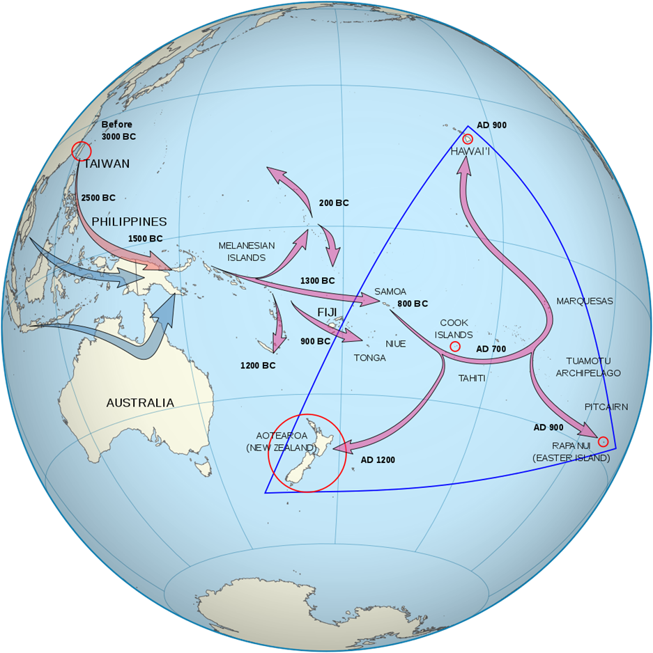
Much of the physical landscape of Oceania has been directly shaped by human activity and settlement. Although Australia today is known for its origin as a British prison colony, the continent was inhabited long before Europeans arrived. The indigenous people of Australia are known as Aborigines and comprise a number of different ethnolinguistic and cultural groups. Most researchers believe the first aboriginal groups arrived in Australia between 40,000 and 50,000 years ago when sea levels were lower and land bridges and relatively short sea crossings separated Australia, Tasmania, and Papua New Guinea from mainland Southeast Asia.
It took thousands more years and advances in ocean transportation and navigation for the rest of the Pacific islands to be settled (see Figure 10.10). Humans gradually made their way to the islands of Melanesia, to Fiji by 900 BCE then east and north. The far-reaches of Polynesia, including Hawaii and Easter Island, were not populated until much later due to the long distances separating them from other landmasses. New Zealand, though, was one of the last to be settled, with Eastern Polynesians not arriving on the islands until around 1250 CE. These groups developed their own ethnic and cultural identity known as the Maori.
Life would change dramatically for the people of Oceania with the arrival of Europeans. The Dutch first made landfall in Australia in 1606 CE but simply explored and mapped the area and did not establish a settlement. In the late 18th century, the British established their first Australian settlement in what would later become the city of Sydney with the intention of creating an overseas penal colony. However, many of the prisoners sent to Australia were not hardened criminals who needed to be separated from the British Isles by an expansive ocean. Many were accused of petty crimes like theft and even children who had committed crimes were shipped to Australia. Today, around 20 percent of Australians are the descendants of these imprisoned settlers.
European settlement of Australia challenged aboriginal land and water resources, but it was disease that had the most devastating effect on the indigenous population. At the time of British colonization, there were likely between 315,000 and 750,000 Aborigines in Australia. By the start of World War II, diseases like smallpox and measles reduced their numbers to just 74,000.
New Zealand was originally claimed by the British as a colony of Australia, but then became its own colony in the mid-19th century. Around the same time, representatives of Britain as well as Maori leaders signed the Treaty of Waitangi. This treaty granted British colonists sovereignty over the governing of New Zealand but gave the Maori the rights to their tribal lands and resources and made them British subjects.
Throughout the 19th and 20th centuries, European and Japanese colonial expeditions claimed most of the Pacific islands. Some islands were seen as strategic military bases. Others, such as France’s colony of New Caledonia, were transformed into overseas prison colonies following the British model. Still others were occupied for their resources and trade opportunities. In the decades following World War II, a number of islands achieved independence. Australia slowly increased its autonomy throughout the early 20th century, officially dissolving from British control in 1942. New Zealand gained independence from Britain in 1947. In the 1970s and 1980s, another wave of independence occurred, with Fiji, Tonga, and a number of other states gaining independence.
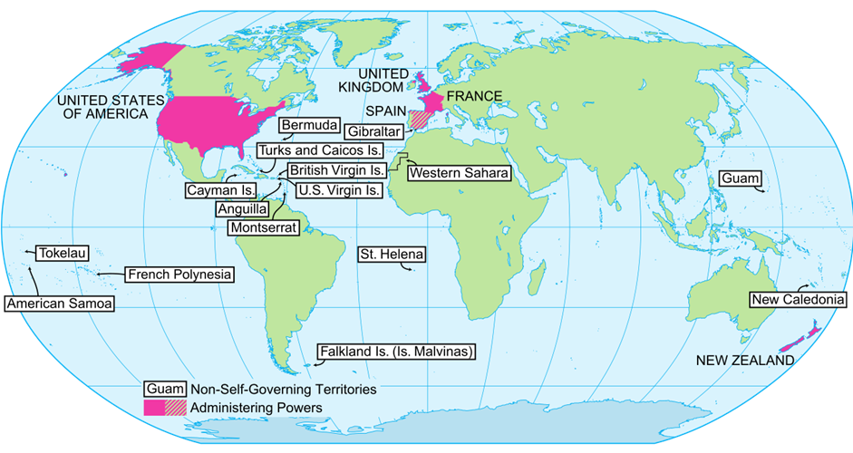
Others were not granted independence and a number of Pacific islands remain colonies today. Hawaii was made a US state in 1959 largely against the wishes of its indigenous population. Guam became a strategic US Naval base in the Spanish-American War and later in World War II and remains a US territory today. Its residents are US citizens but cannot vote in elections. The vast majority of the world’s remaining colonies today are islands because of their strategic locations and resource potential, particularly after the United Nations Convention on the Law of the Sea (see Figure 10.11).
Although Australia and New Zealand gained independence relatively early compared to many of the other areas of Oceania, these countries have experienced lingering issues related to their indigenous populations. For Australian Aboriginals, there were two historical issues they sought to address: the government admission of mistreatment and ownership over tribal lands. Previously, the Australian government ruled that Australia prior to British arrival was considered terra nullius, or nobody’s land, and thus there was no regard for indigenous rights to land or resources. In 1992, however, Australia’s high court ruled that land policy was invalid. By this time, Australia’s Northern Territory was already considered aboriginal land, but later courts found that over three-quarters of the land in Australia could be subject to aboriginal claims, even though Aborigines comprised only 3 percent of the population of Australia. In 2008, the prime minister of Australia issued a formal apology to the Aboriginal people of Australia on behalf of the government.
One challenge to these perhaps promising legal developments, however, is that private enterprise is prohibited on aboriginal land. Even building a home is seen as a violation of the current guidelines. Thus, many Aborigines became land-rich as a result of the government’s decision, but still remained poor. Unemployment, alcohol abuse, food security, and land reform continue to be significant issues for Australian Aborigines. Today, there are over 500,000 Aboriginal Australians and almost one-third now live in Australia’s major cities.
The Maori of New Zealand make up a much larger portion of the country’s population at around 15 percent. The Maori have generally kept their traditional cultural and linguistic traditions while partially integrating into more western New Zealand society. Compared to other groups in New Zealand, the Maori have lower life expectancies and average incomes, and make up around 50 percent of New Zealand’s prison population.
Economically, Australia and the Pacific islands have struggled with what could be called the “tyranny of distance,” the fact that this region remains so far and so isolated from the other world regions. Most of the economies of these countries are based on exports, but these exports must be shipped, adding on to the cost of production. Anything that is not made locally must also be shipped in and some countries have promoted import-substitution industries, a strategy to replace foreign imports with domestic production of goods. Australia remains relatively unique among more developed countries in that its economy is based heavily on the export of commodities. Geography plays a key role in Australia’s export-oriented economy. The country is relatively large and has a significant amount of natural resources. Its domestic population compared to its size and resource base is quite small, at only 24.6 million people as of 2017, so it is able to export the resources it doesn’t need domestically. The country is the global leader in coal exports and has the second-largest diamond mine in the world.
Across the smaller islands of the Pacific, geography has also played a key role in economic development. These countries are often very small with only limited natural resources. They are also remote, only connected by long shipping routes to other world regions. Many rely on trade to Australia, New Zealand, China, Japan, and the United States for both export income and imported goods. Often, residents of the Pacific islands speak Pidgin English, a simplified form of English used by speakers of different languages for trade, in addition to their native tongue. Tourism has become a significant source of income for some countries of the Pacific, especially for the islands of Fiji. Despite some economic successes, these are also some of the world’s most vulnerable countries in terms of global changes in climate and the coming decades could see significant changes in the human landscape as a result.
10.5 The Changing Landscape of Oceania
The human settlement of Oceania, from the earliest migrations to European colonization, has reshaped the physical landscape of this region. Environmental degradation, disturbances to resources like air, land, and water, is a serious concern as economic growth often comes at the expense of environmental sustainability. In Australia, for example, wide stretches of previously sparsely inhabited Outback have become grazing lands. In Papua New Guinea illegal logging has contributed to significant deforestation. Pollution from dairying in New Zealand has led to high levels of water pollution.
Invasive species have also had significant environmental impacts in a region that has been otherwise relatively isolated. Australia has strict quarantine laws in an attempt to limit damage from nonnative plants and animals. The country currently spends around $4 billion yearly in invasive weed management alone. Cats have been banned in parts of New Zealand where they pose a threat to local bird species. Rats brought by early European ships have presented a significant problem for many islands of the Pacific where they kill other plants and animals and also spread disease. Offshore, invasive fish and algae species have damaged fragile ocean ecosystems.
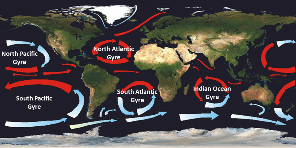
In addition to local pollution concerns, human settlement of other world regions has contributed to pollution in the Pacific Ocean. Worldwide, there are five main ocean gyres, large systems of rotating ocean currents (see Figure 10.12). In the northern Pacific Ocean, one gyre has very high concentrations of trash and plastics carried to the area by ocean currents. It has been termed the Great Pacific garbage patch. When you throw something “away” improperly, these gyres are really where “away” is. A water bottle improperly disposed of on the western coast of North America will make its way to the Great Pacific garbage patch in around six years.
One issue with plastics is that they don’t biodegrade, and instead keep breaking down into smaller pieces while still remaining plastic. Fish and other marine life eat these tiny bits of plastic, which can disrupt a number of biological systems. Some of these fish species are then consumed by humans. Because the Great Pacific garbage patch contains such small pieces of plastic, and most of the plastic is below the surface of the ocean, it is not easily visible with the naked eye and it is difficult to estimate its size. Some have theorized the patch is as big as or bigger than the US state of Texas, while others note that the idea of a “patch” of garbage is really a misnomer as there are concentrations of trash throughout the world’s oceans.
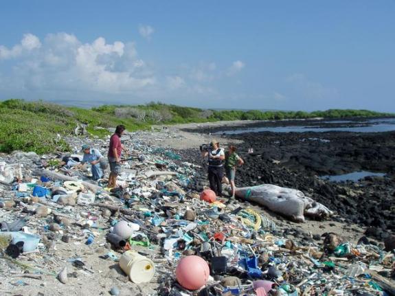
Trash from other world regions also washes up along the shores of the Pacific islands. Kamilo Beach in Hawaii is the site of a significant amount of plastic that has washed ashore from the Great Pacific garbage patch, so much so that the area has been nicknamed “Plastic Beach” (see Figure 10.13). Though the shoreline looks sandy, 90 percent of it is actually bits of plastic and you would have to dig down at least one foot to reach grains of sand. Plastic trash litters many of the shorelines of the Pacific islands presenting a hazard for marine life and a management and cleanup challenge since debris often comes from thousands of miles away.
It is changes in global climate, however, that pose the most severe environmental threat to Oceania. For many of the world’s regions, changes in climate are viewed as hypothetical. Hurricanes might increase in intensity. The risk of fire might increase. Changes in bird migrations in Europe and North America to shifts in global fish stocks have already been linked to increases in global temperature but with little direct effect on the human populations of these regions. In Oceania, though, small increases in temperature and ocean levels could have disastrous effects on already fragile ecosystems and economies.
The Great Barrier Reef is currently experiencing periods of coral bleaching due to increasing ocean temperatures. When waters get too warm, coral experience “stress” and expel the colorful, algae-like organisms that live within them. Mass coral bleaching has occurred several times since the late 1990s and is expected to become a regular occurrence as ocean temperatures continue to rise. Coral bleaching has also been documented in other reefs including ones in Hawaii.
Some of the leaders of the Pacific islands have been among the most vocal champions for global climate regulations. Speaking in 2015, the prime minister of Fiji, Frank Bainimarama did not mince words: “Unless the world acts decisively in the coming weeks to begin addressing the greatest challenge of our age, then the Pacific, as we know it, is doomed.” Fiji has already experienced an increase in infectious diseases related to higher temperatures, record-breaking high tides, and has had to relocate citizens due to rising ocean levels.
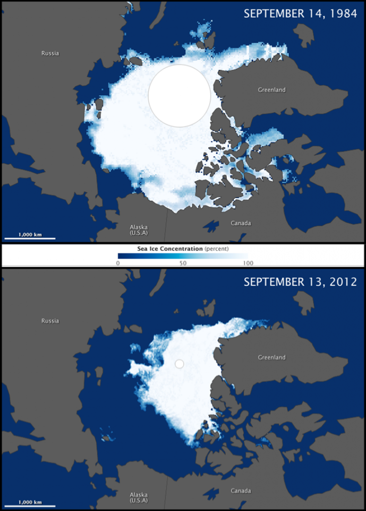
Many of the effects of warming temperatures in the Pacific relate to changes that are first being documented in the Arctic. Scientists have consistently documented the melting of Arctic sea ice for the past decade (see Figure 10.14). As the ice sheets melt, raising global sea levels, the surface becomes less reflective and absorbs more of the sun’s rays, further accelerating warming and beginning a cycle that could be difficult to undo. Both the North and South Poles have experienced faster warming than the rest of the world, and some areas of the Arctic have seen an increase in temperature by 3 to 4 °C (5.4 to 7.2 °F).
The rising oceans in the Pacific and the concentrations of pollution found in this region are stark reminders of our interconnected world. Fossil fuel emissions from a car in the United States affect the amount of greenhouses gases in the atmosphere which in turn can increase global temperatures and melt ice in the Arctic. A plastic shopping bag discarded improperly in Japan makes its way out to sea where it breaks down and forms a coat of plastic sand on a Pacific island. But this same interconnectedness could perhaps be used to our advantage. Small, individual changes magnified across the global system could have profoundly positive effects. In many ways, the future of Oceania will be decided by the actions of global citizens and leaders.
a remote area of extensive grassland pastures in central Australia
a massive underwater coral reef off the coast of northeastern Australia
a large, triangular region of Pacific islands stretching from New Zealand to Easter Island to the Hawaiian and Midway Islands
a region of islands to the northeast of Australia that include Papua New Guinea and Fiji
a region of very small islands north of Melanesia and east of Polynesia
islands that were formed from volcanoes and have relatively high relief
islands that were formed mostly from coral and have relatively low elevations
a ring-shaped chain of coral islands surrounding a central lagoon
a climate zone that features cool summers and cool winters with few extremes in temperature or in rainfall
an area extending 12 miles offshore that is considered sovereign territory of a state
a 200 mile zone extending out from a country’s coastline where it has exclusive control over any natural resources, also known as the EEZ
a branch of geography that explores the spatial distribution of the world’s flora and fauna
having a wide variety of species present in an area
an egg-laying mammal
a species of plant, animal, or fungus that is not native to an area but spreads rapidly
the term for the indigenous people of Australia
the term for the indigenous people of New Zealand
a strategy to replace foreign imports with domestic production of goods
a simplified form of English used by speakers of different languages for trade, in addition to their native tongue
the deterioration of resources like air, land, and water
occurs when coral experience “stress" due to warm waters and expel the colorful, algae-like organisms that live within them
